 |
||
| Detailed
Investigation of the correlation
between the Huygens Mosaics and the Cassini VIMS Images |
||
| February 18, 2005 |
||
|
||
 |
||
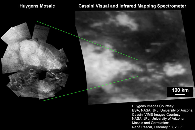
| Comparison of
the Huygens Mosaic and the Cassini VIMS Image of the area where Huygens
landed. For our knowledge of Titan, and the interpretation of many of
the scientific data gathered by Cassini and Huygens, it is of vital
importance to find the correct position for the Huygens landscape
mosaic within the context of the views of Titan obtained by Cassini.
Huygens landed in a very interesting place on Titan, that displays a
diversity of landscape forms; an exact correlation of the landscape
features seen by Huygens to the Cassini views would result in a better
understanding of the large scale surface features seen by Cassini.
Other aspects of this correlation include an independent distance
scaling of the Huygens images. |
||
 |
||
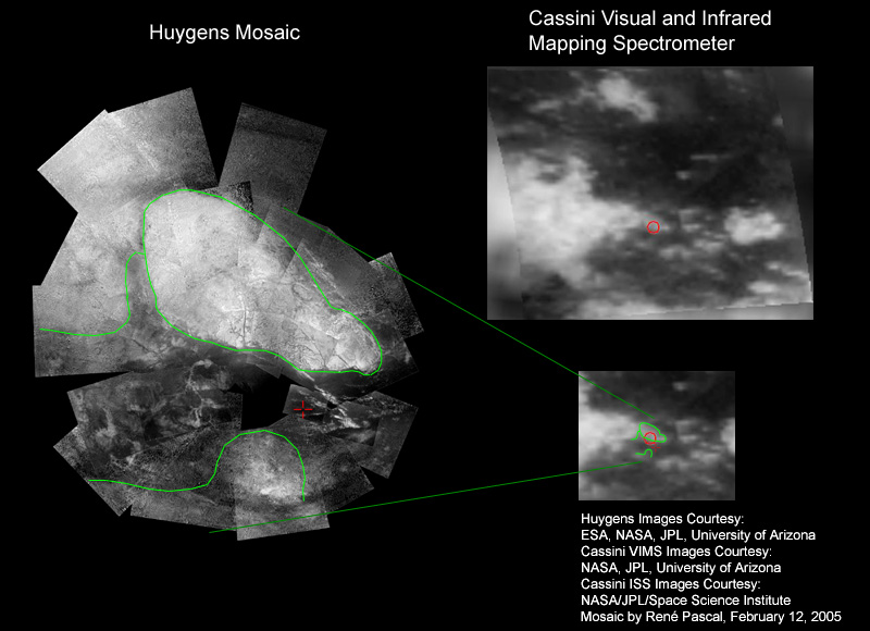
| Comparison of the Huygens wide
field Mosaic with highest resolution Cassini VIMS camera (Visual and
Infrared Mapping Spectrometer) images of Titan. The
outline of the largest features in the Huygens Mosaic can be well
correlated to structures visible in the Cassini Images. The red cross
in
the Mosaic again marks the site of Huygens "soft" landing; this would
correspond to a site in the Cassini ISS images that is also marked by a
red
cross. The red circle is an earlier estimation of the landing site by
ESA / NASA scientists. Comment (March 14, 2005): on the basis of high resolution Cassini ISS images I still suppose the above correlation to be correct in the upper part of the image; the correlation in the bottom has to be slightly corrected as far as I assume these structures to be invisible in the VIMS image. |
||
 |
||
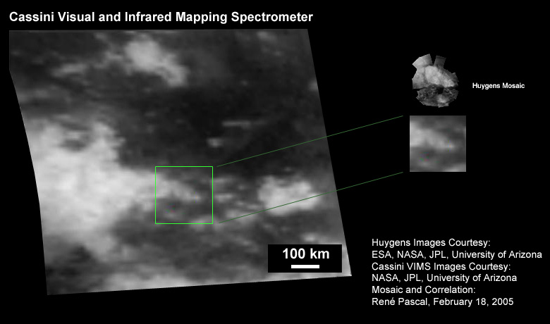
| Is the above correlation between
the
Huygens Mosaic and the Cassini Images correct? The correspondence of a
scaled version of the Mosaic with the Cassini VIMS images seems to be
really good (right), not only the shape is in correspondence, but even
some
bright features within the triangular shaped "island" seem to be
visible
in the Cassini images close to the resolution limit. The large delta
that separates this "island" can be recognized in the Cassini Images,
as well as some structures west (left) of it. Within this triangular
shaped island the correlation is not perfect, especially the
distribution of brighter and darker patches shows many similarities,
but also some deviations. At the point of such a close investigation,
it has to be taken into account that I stitched the mosaic from many
different frames with all of them being image processed to a large
amount, especially the outer ones. Although I tried to obtain a correct
photometric representation of the images within their context,
deviations from the truth may easily be present. A close inspection of selected individual frames
would be necessary at this point. |
||
 |
||
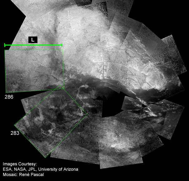
| If
the correlation between the Cassini- and Huygens images of Titan
presented above is correct, this would have some major consequences,
inasmuch as the scales, published together with the
Huygens images up to now, would have to be corrected by a factor of
approximately 2.5. One example for a distance calibration by the Huygens Data: The height above ground that is given for the moment when the triplet frames 283 and 286 have been taken, was between 31km and 25km (see the movie "huygens_landing.mov" for instance, movie frames 29 and 30 ). With the known covering angles (15.75° to 46.25° from nadir) for the DISR Medium Resolution Imager, the distance L of the MRI footprint is: L = 0.75 * H ; H = height above ground. With this formula, the distance L in the image above would be between 20km and 23km. Compared with this value, the calibration that we get from the correlation between the Cassini images and the Huygens Mosaic presented above is by a factor of roughly 2.5 different. This would not only concern the distances between individual landscape features, but also all height above ground values for the same factor. The first images with surface structures visible would not have been taken from a height of 40km, but from 100km, for instance. In this context it should always be taken into account that it is a really difficult task to obtain reliable height above ground informations on a probe, that parachutes through an atmosphere with widely unknown atmospheric parameters. Under these circumstances, it is a masterly performance to get the probe into the atmosphere of Titan in an alive condition. |
||
 |
||
| The correlation I presented above
gives some strong evidence for a visible correspondence between the
Cassini VIMS images and the Huygens Mosaic (correlation A in the image
above). On the other hand, until now it cannot be ruled out that the
similarities in the structures are by accident, and that the Huygens
distance and height calibrations are correct. The triangular shaped
"island" may
then be located at the foremost end of a larger triangular shaped
"island" (as shown in B) with the structures like the large delta west
of the "island" invisible in the Cassini images. Higher resolved images
of this area by Cassini may lead to a definite decision in the future.
I personally suppose the case A) to be the correct one,
with all the consequences of a necessary recalibration of the Huygens
images. |
||